Lütisburg, the Thur, the Necker and the Church of Wila

Lütisburg (canton of St. Gallen) is first mentioned in a document from 1214. The name goes back to the castle that Liuto, a scion of the Toggenburg count family, had built directly above the Thur bridge. The barons of Raron sold Lütisburg in 1468 to the abbot and the monastery of St. Gallen.

In the gorge at Lütisburg, the Thur and the Necker converge. The historic wooden bridge Letzibrücke has been over the Thur since 1789. The Guggenloch bridge of the Toggenburgerbahn was built in 1870.

The “Thur and Necker Path” is a hiking trail project in Toggenburg that connects the river valleys of Thur and Necker.

The church of Wila

Nature

The Village and Propstei of St. Peterzell

The village of St. Peterzell and the Propstei (provostry) of St. Peterzell (canton of St. Gallen) are located on the river Necker. The village owes its name to the provostry. Around 1050, the St. Peterzell Monastery was founded. The nobles of Illnau (in the Canton of Zurich) established it in honour of the Apostle Peter.

As early as the 11th century, three pilgrimage routes converged in St. Peterzell. The first mention of “cella sancti Petri” dates back to the year 1178. A relationship of possession and dependency developed between the Benedictine monastery of St. Johann and St. Peterzell.

The Abbey of St. Gall acquired the St. Johann Monastery in 1555, and with it, St. Peterzell. Subsequently, St. Peterzell gained the status of a provostry.

The neighbouring municipalities are Schwellbrunn (Canton of Appenzell Ausserrhoden) and Degersheim (Canton of St. Gall). Schwellbrunn is included in the register of “most beautiful villages in Switzerland”.

The small village of Au

The village of St. Peterzell

Kyburg Castle and Village

The Kyburg is first mentioned in a document from 1027. The original name was “Chuigeburg” (Kuhburg (Cow Castle). The Count of Kyburg expanded the castle around 1200. The beautiful chapel, parts of the large tower, and some outer walls still stand today.

The 12th-century wall

The Kyburg family, alongside the Habsburgs and the Savoyards, was one of the most important noble families in the area of today’s Swiss Midlands.

The place and the chest (copy) in which Rudolf I and Albrecht I of Habsburg kept the imperial regalia. 

After the death of the last Kyburger in 1264, Rudolf I of Habsburg acquired the area. After his coronation in 1273, King Rudolf I had the imperial regalia handed over to him and kept them at Kyburg Castle.

In the judge’s chamber, the bailiff passed judgment on offences.

Zurich acquired the village and castle of Kyburg in the 15th century and converted it into the residence of the bailliff.

After acquiring and renovating Kyburg Castle, Zurich refurbished the chapel. The murals bear witness to late medieval piety and stately self-confidence.

In 1890, the chapel’s castle was completely repaired and restored to its pre-Reformation ideal condition. In 1866, Switzerland’s first castle museum was opened in Kyburg.

The Bridge over the Töss

The garden was restored in 2001 based on historical sources.


The chapel

The village of Kyburg


La Punt Chamues-ch, Mia Engiadina, and the Albula Pass

The Counts of Gammertingen initially owned the village of Chamues-ch. The Diocese of Chur acquired the village in 1137. The location at the entrance of the valley and at the foot of the Albula Pass was of strategic importance, and Bishop Volkhard of Chur built the Guardaval Castle in 1250. A bailiff resided there on behalf of the bishop.

Around 1440, the bridge over the Inn to the hamlet of La Punt was built, and since then, the village of La Punt Chamues-ch has existed. La Punt (Romansh: the bridge) grew mainly through trade over the Albula Pass and became a trading hub.

Stately patrician houses of trading families remind us of prosperity and trade. Today, La Punt houses the hunting museum (Jagdmuseum) and a Mia Engiadina Hub.

Das Jagdmuseum

Der Mia Engiadia Hub in La Punt

Der Mia Engiadia Hub in Scuol

Chamues-ch mainly served as a residence for farmers. The beautiful old and massive farmhouses in this part of the village, however, almost all date from after 1499, as the inhabitants set fire to their wooden houses during the Swabian War (1499) to force the advancing enemy (Habsburg) to retreat.

Impressions from La Punt Chamues-ch

Tujetsch, the Tomasee, the source of the Rhine and Andermatt

Tujetsch (Tavetsch in German) is a region in Surselva (canton of Graubünden). In this area lies the cradle of the Rhine: the Tomasee. The Oberalp Pass connects the Val Tujetsch with the Urseren Valley,  Andermatt and the Romanesque St. Kolumban Church.

Andermatt

Tujetsch is the name for both the entire valley and the corresponding political municipality. Tujetsch is therefore not a village, but rather comprises the following 11 fractions: Tschamut, Selva, Dieni, Rueras, Zarcuns, Camischolas, Gionda, Sedrun, Bugnei, Surrein, and Cavorgia.

The first settlement of Tujetsch took place after the founding of the Disentis Monastery in the 8th century. In the 12th century, the Walser came over the Oberalp Pass and settled in Tujetsch.

Sedrun around 1930. Picture: Hotel-Restaurant La Cruna

Hotel Krone around 1930

Hotel-Restaurant La Cruna today

Tschamut is the village that lies furthest west in the valley. This upper part of the valley was inhabited by Walser, who had immigrated from the Urseren Valley. Up to Sedrun, the valley is German-speaking.

The name Sedrun is Romansh, and thus even the small municipality of Tujetsch has a language border: Romansh from Sedrun onwards. Sedrun is the political centre of Tujetsch, and the Drun stream divides the village into two parts: Sedrun and Gionda.


Types of rock from the Gotthard Base Tunnel

Impressions from Andermatt

The Wendelin-Chapel

The Oberalppass

40th Anniversary of the Kulturverein Elsass-Freunde Basel

The Kulturverein Elsass-Freunde Basel is organising a festive commemoration on Sunday, September 28, to celebrate its 40th anniversary. It will take place from 10:30 AM to 5:15 PM in Ungersheim, Alsace. The cross-border anniversary celebration is entirely dedicated to the centuries-old neighbourliness.

For four decades, this association has been connecting people in these three regions. An encounter marked the beginning of its existence: Dr. Max Gschwend, the first director of the Ballenberg Open-Air Museum (Canton of Bern), met the Alsatian Marc Grodwohl, the later founder of the Écomusée d’Alsace, in Ungersheim. To promote the Écomusée in Basel and its surroundings, the cultural association Elsass-Freunde Basel was founded in 1985 with its headquarters in Basel.

What started with organised trips to the Écomusée quickly developed into regular discovery journeys and meetings, first in Alsace, then also in Northwestern Switzerland and Southern Baden. The goal remained unchanged: to build cross-border bridges and promote cultural exchange, language, history, population, and landscape.

The morning of September 28 begins with a visit to the “Maison des Natures et des Cultures,” a historic building with an architectural style that showcases local, natural products to the population. Following a joint lunch, a festive ceremony will be held to mark 40 years of association history, featuring a cross-border concert by the Harmonie Vogésia orchestra, conducted by Valérie Seiler.

Details about the program can be found on the association’s website. Registration via the cultural association’s website is possible until September 7, 2025.

(Source and further information: Kulturverein Elsass-Freunde Basel)

A short History of the Avers Valley

The lower valley section (Campsut, Campsur, Cröt, and Platta) was inhabited in Roman times, whereas the upper part, between Cresta and Juf, served only as pastureland. An indication of this habitation is the persistence of Roman names in use today.

The first written mention of Avers (Canton Graubünden) can be found in the statute book of the city of Como from 1289, in connection with the settlement of mercenaries from Wallis in the Avers valley.

Avers belonged to the County of Scham until the mid-14th century. The municipality of Avers had its own seal in 1396. This shows a jumping ibex, indicating the connection with the Gotteshausbund.

Between 1520 and 1525, the inhabitants of the valley converted to the Protestant faith and sided with the Franco-Venetian forces during the Bündner Wirren (1619-1639).

Before the construction of the road to Avers-Cresta as a branch of the Splügenweg in the “Roffla” in the years 1890-1895, there was only a poor mule track between Schams and Avers.

Between 1958 and 1962, the construction of the dam and power plants in the Val di Lei was completed, and the road was extended to the village of Avers-Juf.

Avers-Juf

Thanks to this improved accessibility, tourism also experienced significant growth. Due to its remote location, Avers has been spared from war campaigns and devastation since the 14th century. The culturally and historically valuable buildings, some dating back to the 16th century, as well as the original settlement structures, have been mainly preserved.

Avers-Juf

Scuol, Tarasp and Vulpera

Scuol first appears under the name ‘Schulle in a document from around 1095, in connection with the construction of a Benedictine monastery and a church. The monasteries of Marienberg (Austria) and Müstair, as well as the Habsburgs, owned what is now the Lower Engadine (Unterengadin), including Scuol, for a long time. It was not until 1652 that the villages in this region bought themselves free from the Habsburgs.

Unterengadin and Scuol (Schuls in German) also suffered from the invasions of Austro-Habsburg and French troops. In 1499, in connection with the Swabian War (Swabische Krieg), Emperor Maximilian’s soldiers plundered all the municipalities in the Unterengadin region.

During the Bünder Wirren (1618-1639) in the Thirty Years’ War (1618-1648), Austrian troops tried in vain to conquer Scuol. French occupiers also held sway during the French era (1798-1813).

The San Geer (St. George) church was built at the beginning of the 16th century and was consecrated in 1516. The Reformation was introduced in Scuol in 1530. As a result, the interest in the written word grew.

In 1679, the first “Bibla da Scuol” in Romanic (Vallader) appeared in the printing house of Jachen Dorta. The “Gazetta ordinaria da Scuol”, the first newspaper in Graubünden, appeared from 1700 to 1726.

The Printer in Scuol

The first ‘Bibla da Scuol’, Unterengadiner Museum. 

Many inhabitants of the Engadine and the new canton of Graubünden (founded in 1803) emigrated. Many entered foreign military service as mercenaries or worked abroad as pastry makers or merchants.

The mineral springs, landscape, and climate formed the basis for developing Scuol into a health resort. In 1850, the first analyses of water were carried out. Between 1860 and 1915, most hotels in Scuol and Vulpera were constructed.

Stradun 402

A remarkable building is located at Stradun 402 (Main Street 402). The house was built in 1869 by Sidonia Biveroni from Bever. The new owner, Otto Töndury, set up a bank and a pharmacy in the building.

Scuol experienced a great boom and prosperity thanks to tourism, mineral springs and health resorts. Surrounding towns such as Tarasp, Vulpera, Val Sinestra, and Sent experienced a similar boom.

In 1905, Bernese artist Otto Haberer (1866–1941) decorated the façade with figures from the history of the Engadine and Graubünden:

Benedikt Fontana (1450–1499), Johann Jeuch (1508–1578), Johann Luzi Gugelberg von Moos (1562–1616), Anton von Molina (1585–1650), Johannes von Tscharner (1593–1659), Georg Jenatsch (1596–1639), Pompeius Planta von Wildenberg (1570–1621), Fortunat von Sprecher (1585–1647), Johann Simeon von Florin (-1644), Ulysses von Salis (1594–1674) und Johann Guler von Weineck (1570–1637).

Today, the building houses an interior design shop and apartments.

(Source and further information: www.scuol.net)

Vulpera, Hotel Schweizerhof. Photo: TES.

The Tinkhalle and the Inn (En in Romansh).  Photo: TES.

Tarasp and the castle. 

The motorway through the Engadine and to Scuol (1860) and over the Flüela pass (1867) promoted tourism, and Scuol-Tarasp-Vulpera became a name of international fame. The Grand Hotel Walhaus in Vulpera, which burned down in 1989, was one of the most luxurious and well-known hotels.

However, the two world wars and the development of new medical treatments took their toll, and the Grand Hotels either closed or burned down (whether or not for insurance premiums, like the Waldhaus in Vulpera). In 1950/51, the first winter season was introduced. In 1956, the first lift was built.

Bogn Engiadina

Today, Scuol is a modern tourist centre offering a range of possibilities for sports, entertainment, and recreation throughout the year, as well as Roman language courses in the summer.

Tourism and the economy have developed in Scuol. The organisation Mia Engiadina is one example among many.

Hotel Bellevue and the Inn (En in Romansh)

The Inn and the bridge to Vulpera and Tarasp

The Hinterrhein as a Walser and Romansh cultural and trade route

A journey along the Hinterrhein begins at Graubünden’s oldest Walser village. The village is named after the southern source of the Rhine, the Hinterrhein. The Vorderrhein rises in the St Gotthard massif. At Reichenau, these rivers meet.

The Hinterrhein near Hinterrhein

Hinterrhein (canton of Graubünden) is 1 kilometre from the San Bernardino tunnel. The valley extends another 10 kilometres to the Rheinwaldhorn, which also marks the border with the canton of Tessin. The Hinterrhein rises in the Paradiesglacier, which lies between the Rheinwaldhorn and the Rheinquelhorn.

The Hinterrhein, the 1693 bridge and the valley towards San Bernardino 

The village is a centuries-old transit point for traders and other travellers, over the San Bernadino Pass to the Italian-speaking Val Calanca (Canton Graubünden), over Valserberg to the Walser village of Vals, via Splügen and Nufenen over Safierberg to Safiental, over the Splügen Pass to Chiavenna (Italy) or via the Rofflaschlucht and the Viamala to Reichenau-Tamins.

The Viamala

The Romans already used this route, and until the arrival of trains and cars in the 19th and 20th centuries, the primary means of transport were horse-drawn carriages, later replaced by diligences, stagecoaches, and mules or donkeys.

Collection: Museum Rheinwald

Transport with (mule) donkeys was the primary means of transport for traders until the advent of trains and cars. This trade is referred to as Säumerei over Saumwegen. The Museum Rheinwald in Splügen pays extensive attention to the history of the Säumer (traders).

Villages along the route benefited from this traffic route for centuries. The (valuable) goods were mainly stored in a large warehouse (Sust). Food products, wine, olive oil, skins, as well as luxury items such as silk, were transported along this route.

Collection: Museum Rheinwald

Inns for merchants (Säumer), coachmen, and passengers, as well as food and changing places for horses and other animals, carriages, repair shops, blacksmiths, farmers, and various other suppliers and service providers, brought prosperity and employment to this international transit route.

The trading houses and town palaces in these villages recall this period. However, the traditional wooden Walser houses and warehouses are in the middle of it all. Entrepreneurial spirit, tradition and innovation in Switzerland.

Hinterrhein

In the second half of the 13th century, German-speaking Walser settled at this spot in the Rheinwald forest. The Walser were immigrants from Valais. They likely emigrated in large numbers to Graubünden and other regions due to population surpluses and succession issues. From the village of Hinterrhein, they then headed towards Vals, Splügen and other areas of Graübünden.

Treaty between Lord Von Sax Misox and the Walser in Hinterrhein, 1286. Collection: Hinterrhein Archive

The Walser received permission and (tax) privileges from the owners of these lands. The Lords von Sax Misox (Burg Messoco) and Von Vaz concluded treaties with the Walser.

Nufenen

Further downstream is the Walser village of Nufenen. The Walserama documentation centre provides extensive information on the Walser people, their culture, trade, language and agriculture.

Splügen

The village is considered, so to speak, the model village for transit with its Walser buildings and stone Italian town palaces. The Museum Rheinwald is housed in one of these palaces. The Heimatschutz awarded Splügen the Wakkerpreis in 1995. The viaSpluga is a hiking and cultural trail between Thusis (Via Mala) and Chiavenna over the Splügen Pass.

Sufers

Today, the village is best known for its reservoir and power station, as well as the gigantic Crestawald fortress, built during the réduit period (1940-1945) as a defence against the Italian dictatorship.

Schams

The originally Romansh-speaking area includes the villages of Via Mala, Rofflaschlucht, Val Ferrera, Andeer, and Zillis, as well as several small hamlets. Until the 20th century, Romansh remained the dominant language. Walser did not settle in large numbers in the 13th century, but German-speaking Swiss did after 1800.

Zilllis

Andeer

Further downstream is the town of Andeer.  Until a few generations ago, Andeer was also a village where Romansh was spoken.  The construction of the Via Mala in 1473 and the establishment of new traffic routes in 1818-1822 led to a significant increase in prosperity, employment, and population in Andeer as well.

The Rofflaschucht and its Gasthaus also benefited until the Gotthard railway tunnel and the arrival of cars.

Reichenau

The Hinterrhein and the former Säumerweg continue their route, passing through Thusis, Fürstenau, Rhäzuns, and Bonaduz to merge with the Vorderrhein and its Säumerweg at Reichenau-Tamins.

Conclusion

What today are comfortable roads with the Via Mala and the Rofflaschlucht as tourist attractions, were for centuries dangerous and necessary traffic arteries in all (harsh) seasons.

The arrival of the Walser led to the establishment of new villages, the adoption of different agricultural methods, house building, and language, as well as the rapid development of trade and traffic routes, and the clearing of forests due to the great need for wood.

From Andeer onwards, the Romansh language survived for a long time, only giving way to German during the late 19th and 20th centuries. Today, there is again more interest in and use of the Romansh language.

Switzerland is (for the time being) a successful melting pot of languages, cultures and religions, and Graubünden, with its Italian, German, Romansh and Walser roots. However, the country also marks the maximum achievable and further ambitions might well have unforeseen and not necessarily positive consequences.

The Viamala


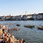
Swimming in the Rhine

The annual Basler Rheinschwimmen (Basler Rhyschimme) took place on 12 August. The start was punctual at 18.00 with the traditional cannon shot. The course is 1.5 km from the Tinguely Museum to the Johanniter Brücke on the Kleinbasler bank.

A few Baslers swim in the Rhine every day from spring to autumn, weather or no weather. The brave ones even hold out in the winter months. In the summer months and especially with good weather, the Rhine is an open-air swimming pool.

The annual Rheinschwimmen brings together thousands of swimmers. The event is organised by the Schweizerische Lebensrettungs-Gesellschaft (SLRG) Sektion Basel.

The swimmers enter the starting point in a festive procession and then enter the water (at 23.5 °C). Despite the low Rhine level, the Rhine is still heading towards Rotterdam. After 1.5 km of floating/swimming downstream, a musical and culinary welcome awaits at the finish.

Logo: www.sport.bs.ch