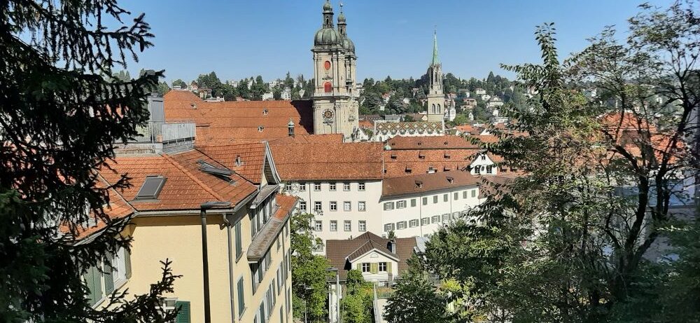
St. Johann and Johanneum

The first document mentioning the monastery of St. Johann (canton of St. Gallen) dates back to 1152, when Pope Eugene III (pope from 1145 to 1153) took the monastery under his protection.

One of the reasons for the foundation was the geographically favourable location between the monasteries of Pfäfers, Einsiedeln and St. Gallen. It was the last of the old Benedictine monasteries in Switzerland. 

The relatively short period of prosperity ended in the 16th century because of the Reformation. The abbey of St. Gallen took over the monastery in 1555.

Two devastating fires occurred in 1568 and 1626. The prince-abbot of St. Gall decided in 1629 to move the monastery to what is now Neu St. Johann. The new monastery (today’s Johanneum) is, together with the church consecrated in 1680, one of the most important buildings of the Swiss early baroque.

(Source: D. Studer, Das ehemalige Kloster St. Johann im Thurtal, Bern, 2002).

Chapel Bridge Lucerne

The Chapel Bridge (Kapellbrücke) in Lucerne was built around 1360 and is the oldest wooden bridge in Europe. The Chapel Bridge and the water tower are the landmarks of Lucerne. Together with the Spreuerbrücke, located further downstream, it bears witness to the city’s medieval history.

In the 17th century, the image cycle on the bridge was created, depicting the history of the Confederation and the city saints of Lucerne, St. Leodegar and St. Mauritius. In 1993, however, a fire destroyed large parts of the Chapel Bridge. The bridge and several images were restored.

(Source: www.kapellbruecke.com).

Maloja and Nature

The geological rocks at Maloja are 300 million years old. The forces of water and ice, plants, animals and humans shaped the unique landscape of the Maloja Pass.

This pass also provides suitable conditions for bird migration across the Alps. The glaciers and climate have created the conditions for the formation of the heaths and marshlands of Maloja.

When the glaciers melted at the end of the last Ice Age, lakes and marshes formed. The Palü Marcía swamp, located near the Maloja Pass, is approximately sixteen thousand years old.

The Alpine areas of the Upper Engadine, located at an altitude of 1700-1800 m, are unique. The forests have recovered from centuries of human use for grazing, firewood and construction. The Belvedere tower, owned by Pro Natura, offers an exceptional view to enjoy this landscape.

(Source: www.pronatura-gr.ch).

Monastery and City of St. Gall

The monastery of St. Gall was founded in 719. Its history began with the legend of the Irish monk St. Gallus (c. 550-640), who died at this site. Traders, farmers and craftsmen settled in the neighbourhood after 720, the beginning of the town of St. Gall.

The ‘Gallus’ Stream Steinach in St. Georgen. According to the legend, Gallus walked around 612 from Arbon to St. Georgen and followed the stream. He stumbled and settled on that location, the place of the later St. Gallus Chapel in St. Gall. 

The monastery, library, and archives were added to the UNESCO list in 1983. The decisive factor was the combination of the 18th-century baroque monastery complex with a tradition dating back to the 8th century.

The SBB Railway Station

The City

The latter manifests itself hardly in the architecture but in the abbey archives and library. The library is one of the oldest and richest in the world. The monastery was abolished in 1805.

(Source: E. Tremp, J. Huber, K. Schmuki, Stiftsbibliothek St. Gallen, St. Gallen, 2007; www.stiftsbezirk.ch).

Impressions from the abbey, the archive and the library


The Gallus relic

The Gallus bell

The entrance of the library and the Greek words (freely translated) “balsam for the soul”.

The Notker Globus (2022), construction based on the above text from 1015. The globe is round and not flat, centuries before Gallilei!

The Zeichen des Himmels, around 450, is the oldest manuscript in the library.

The St. Galler Globus, 1576. Replica. The original is kept in the Landesmuseum Zurich

De St. Galler Globus, 1576. Landesmuseum Zurich

Kloster became Klosters

The monastery is first mentioned in 1222 in a bull by Pope Honorius III (1150-1227). The name of the village Klosters is derived from this.

The barons of Vaz were its patrons. The valley and the village came into the hands of the barons of Toggenburg in 1338. The Counts of Montfort inherited the town of Klosters and sold it in 1477 to Duke Sigmund of Austria.

The founding of Zehngerichtebund took place in 1436 in Davos. When the three unions (Gotteshausbund, Grauer Bund and Zehngerichtebund) united in 1471, Klosters became a member as a Gericht, but at the same time remained an Austrian subject. The Free State of the Three Unions (Freistaat der Drei Bünde) was founded in 1524.

Klosters changed religion in 1525 and dissolved the monastery. In 1649, the ten Gerichte bought themselves free from Austria. In 1803, Graubünden joined the Swiss Confederation (Act of Mediation), which existed until 1813, as well as the Confederations of 1815 and 1848.

In 1852, the first hotels were built. The Landquart-Klosters line of the Rhaetian Railway became operational in 1889.

(Source: www.klosters-serneus.ch).

Rapperswil, Habsburg and the Confederation

The original residence of the Counts of Rapperswil was in Altensdorf (Schwyz Canton). The counts profited from the important trade route over the mountain passes in Graubünden to Lombardy and Venice.

The Counts settled on the hill of today’s castle in Rapperswil in 1220. It is the origin of the town. The opening of the Schöllenschlucht around 1220 created a more direct transit route over the Gotthard, likely contributing to this change. The lucrative pilgrimage route to Einsiedeln via Rapperwil may also have been a motive.

Rapperswil has been an independent city parish since 1253; previously, the church was under the control of the Pfäfers monastery. The first (Romanesque) church was built on Castle Hill in 1229. The dukes of Austria, the Habsburgs, took control of the city in 1354.  Rapperswil became a free imperial city in 1415.

The town allied with the Confederation (Eidgenossenschaft) in 1458. The Orte Schwyz, Glarus, Uri and Unterwalden (1464-1712) and later Bern, Glarus and Zurich (1712-1798) were the ‘supervisors’ (Schirmorte).

The canton of St. Gallen was founded in 1803, and the town of Rapperswil acquired ownership of the castle. The neo-Gothic church, featuring dissimilar Romanesque-Gothic towers, was built after a fire in 1882.

Monument for Poland

“Polens unsterblicher Genius nach hundertjährigem Kampf mit der Gewalt noch unbesiegt ruft auf Helvetiens freiem Boden zur Göttlichen und meschlichen Gerechtigkeit”.

The Polish Museum in Rapperswil (Canton St. Gallen) documents Polish-Swiss relations for several centuries.

It presents Polish culture and history, tracing the Poles’ struggle for freedom, rooted in tradition. The museum also showcases the contribution of Poles to Switzerland’s material and spiritual culture.

Laser Lightning Rod

As the national weather and climate service, MeteoSchweiz conducts weather and climate measurements at all times on Swiss territory. The complex topography of the Alps represents a real challenge.

The Säntis also has a station (SwissMetNet). Switzerland’s complex alpine topography presents a particular challenge. A new project on the Säntis is called Laser Lightning Rod. Since the invention of the lightning rod by Benjamin Franklin (1706-1790) in 1752, science has been working to understand the natural phenomenon of lightning.

Due to the rapid development in laser technology, a new type of lightning protection is being investigated. The ‘Laser Lightning Rod’ project aims to examine and develop a new laser lightning protection system.

(Source: www.MeteoSchweiz.ch).

St. Evortius Chapel

In the 10th and 11th centuries, the Pfäfers (canton of St. Gall) chapel was a church within the medieval Pfäfers monastic complex.

The church was dedicated to St. Evortius of Orleans.  Around 900, the chapel was built in his honour. The relics are mentioned in the reliquary of the Pfäfers monastery in 880.

The small chapel had three altars. The oldest depiction of the monastery and chapel dates back to 1386. The present-day chapel was built in 1625.

Urnäsch, the largest municipality of Appenzell Innerrhoden

Urnäsch (Canton Appenzell Innerrhoden) is a street village on the left bank of the Urnäsch and, in terms of area, the largest municipality in the canton.

The name ‘Urnasca’ appears as early as the 9th century. Under the rule of St. Gallen Abbey, the village first formed a district with Herisau.

In the 14th century, it was a rhode (part) of the district of Hundwil. In 1377, it joined the Swabian League of Towns, and in 1401, the League expanded to include the town of St. Gallen. Political independence was achieved in 1417. In 1525, the village converted to the Reformed religion. Since the land division in 1597, Urnäsch has belonged to Appenzell Innerrhoden as one of the seven Rhodes.

(Source: www.urnaesch.ch).