
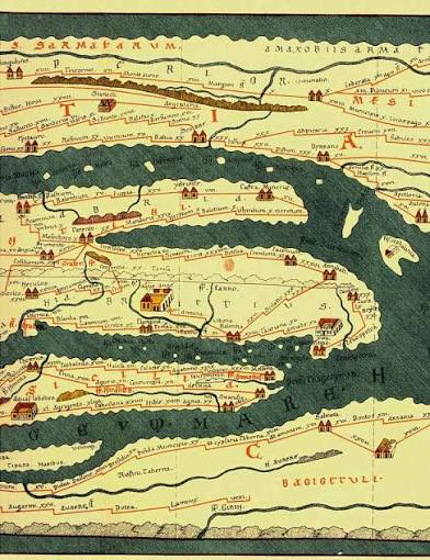
Switzerland on the Tabula Peutingeriana
10 October 2026
The Peutinger Map (Tabula Peutingeriana) is a copy of a Roman road map showing the most important roads and towns of the Roman Empire – in a sense, an ancient version of a digital map.
The original was engraved on the Arch of Agrippa (Porticus Vipsania or Porticus Agrippae) in Rome around 12 BC. Emperor Augustus had conquered further territories, including the area that is now Switzerland. The Roman Empire stretched over 8,000 kilometres from west to east, which at the time corresponded to around 300 days’ march on foot.
This depiction of routes served not only as propaganda, but also as a guide for merchants, armies, traders, diplomats, politicians and other travellers. It is likely that this map was also available on a smaller scale on parchment, but nothing is known about it and no such copies have survived.
The cursus publicus
The Romans were builders of cities, roads, bridges, and had even established a well-functioning postal service, the cursus publicus. For this reason, the map also shows stopping and resting places along the cursus publicus. They all relied on clear route descriptions, and this map was the basis for them.
The map also gives distances in Roman miles (1,482 metres). Furthermore, it shows rivers, seas, oceans, islands, lakes, mountain ranges, forests, significant structures, mountain passes, bridges and harbours. The three most important cities of the empire – Rome, Constantinople and Antioch – are also specially marked. In short, it is a Roman marvel of cartography, even though the map is difficult to read today due to the lack of geographical proportions and orientation.
However, this does not detract from the fact that the information it provides is of great value for locating the most important places in the Roman Empire. The map shows 37 places within the territory of present-day Switzerland or immediately beyond its borders, including Augst/Kaiseraugst, Nyon, Geneva, Windisch, Arbon, Bad Zurzach, Avenches, Chur, Yverdon-les-Bains, Martigny, Moudon, the Great St Bernard Pass, Solothurn, the Rhine, the Rhône, Lake Geneva, Lake Constance and Lake Maggiore.
Be that as it may, the original in Rome has not survived. In the 12th century, monks from Colmar produced a copy on twelve sheets, based on a lost copy on paper or parchment. Eleven of these sheets have survived and are held by the Nationalbibliothek (National Library) in Vienna.
Together, these sheets measure 6.82 metres in length and 34 centimetres in height. The map bears the name of its last owner, Konrad Peutinger (1454–1547). This document has been inscribed on the UNESCO Memory of the World Register since 2007.
(Source and further information: Österreichische Nationalbibliothek)